| Hike through Britain with Daryl May | |
| Overview | |
 |
|
Northbound Home Southbound Home Overview of both hikes Excerpts Statistics What others say Acknowledgments Contact me Copyright Links |
Famous
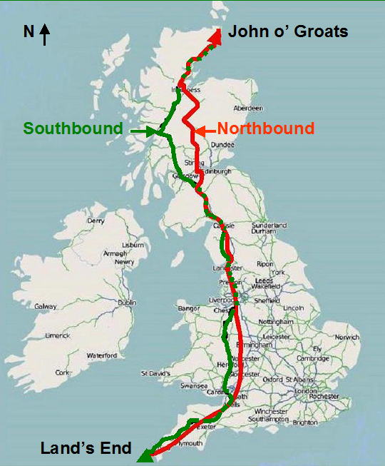
British hike, the "End-to-End" between Land's End and John o' Groats Two hikes - - Northbound: 928 miles, 56 days, Mar-May 2007 - Southbound: 971 miles, 65 days, Feb-Apr 2008 Averaged 15 to 17 miles per day Alone, carrying backpack and bellypack (24 lb) Stayed at B&Bs, inns, youth hostels, hotels and with friends Numerous blisters, one debilitating - ankle and knee pain, aching shoulders, sunburn - and a large hernia Lost 13 lb each hike, grew new muscles Ended nearly broke |
|
.
Never let dreams die on your pillow. As a retired American of 63 years, I returned to my former British life to fulfill a 50-year-old dream - to hike “end-to-end” - from the southwest tip of England to the northeast tip of Scotland. Then, for reasons I can hardly explain, I returned a year later and hiked back. In doing these hikes, I also stepped through my own life, and rediscovered Britain after a 40-year absence. So these pages tell a personal story alongside a hiking one. This isn't just a travel guide, but nostalgic entertainment - when reading it, think of yourself in a leather armchair in front of a winter fire, sipping at the red wine of my youth, and perhaps enjoying the bouquet of your own. Who knows, my story may also fulfill another purpose: “Reminding
one another of the dream that each of us aspires to may be enough for
us to set each other free” (Antoine
de Saint Exupéry).
The box above describes my trip in purely hiking terms. In more personal terms, I hassled with accommodation challenges, witnessed dogs and a dogfight, sampled British plumbing, cheeses and pubs, fought battles with Internet providers and boot suppliers, talked to cows and sheep, recalled my digs as a student, reflected on my mother-in-law’s hemorrhoids, rediscovered Charles Darwin and cucumber sandwiches, experienced lime pickle and a “reverse buffet”, shared a Scottish youth hostel room with two Spanish ladies, squelched through manure and a sewage plant, waved to Scottish Hell’s Angels and spent an evening with the Hikers from Hull, suffered the dollar exchange rate - and a really gross blister - and made friends with the memorable but imaginary Arthur Bourke-Stewart. While the labor of the hike often preoccupied me, I was sometimes able to explore my inner thoughts. As Oscar Wilde said, “We don’t receive wisdom; we must
discover it for ourselves after a journey that no one can take for us
or spare us.”
The towns and villages that I stayed at are listed here, along with mileage and time information. Actual establishment names, prices, and my quality ratings are given on the webpages for each day. The map above shows my approximate routes. With time available to me more recently, I've also added route maps on each of the pages which introduce the various regions (e.g., "English West Country"). My route is traced there between the places I stopped each night. On those pages, you'll also find a link to some zoomable maps I've created using Google Maps. Those zoomable maps allow anyone interested to pretty-well follow in my footsteps on satellite photographs. In some parts of the country, those maps have a resolution allowing one to view objects as small as a car. In others, at least the route itself is quite clear. * The zoomable maps also serve a purpose besides navigation. By showing each little stretch of trail or road, they bring home the distance involved in a hike like this. I don't pretend that the end-to-end hike involves heroics - enormous numbers of people have done far more - but it nevertheless ranks right up there as a personal challenge. The zoomable maps show the detail that brings this fact home. True mapping fanatics (I'm one) can also make use of the following to supplement what I've provided: 1. Ordnance Survey provides free high-quality hiking maps on-line, though only for limited use. I can't reproduce them, but you can selectively view the same maps as I used. Just insert a place name at their Get-a-map site, and go from there. Then use the + to - snake for zoom control. 2. Superior city detail helps make http://www.streetmap.co.uk a flexible resource that can take you right from named local streets to an entire region. If you have an address, it will also allow you to find it by inputting a postal code or street name. This is a powerful way to locate a B&B when you have its address but no map location. There's
a tongue-in-cheek thread also running through this website. I've
observed - and exhaustively used - roadside benches for nearly
two thousand miles in Britain, and they're a distinctly diverse bunch.
My Benches of Britain
photo collection is spread across a number of the Southbound pages
which I hope will bring chuckles. The first of them is day
S25, where you'll find links to the others.
* On the zoomable maps, you may find my route lines and notes seem to be partially missing. This is a limitation of Google Maps' ability to hold a lot of such data on one page. To find what's missing, scroll to the bottom of the left column and toggle between the Next and Previous page options. Google Maps imagery is periodically updated, with a couple of interesting (though unimportant) consequences as far as following my route. You'll notice that one of the zoomable maps shows me walking on a motorway north of Carlisle, whereas at the time of the hike the "motorway" was actually an A-road. On occasions, the Google updates also reposition a map feature for greater accuracy, and my route may then appear a short distance from where you'll recognize that it ought to be. |
|
|
© 2007 - 2009 Daryl May.
|
|