| Start
Intro
Day
A17
Day A19 |
| Day A18 - The mighty
Mistral |
| April
19,
2013
Istres-nord to St. Martin-de-Crau
15 miles |
 |
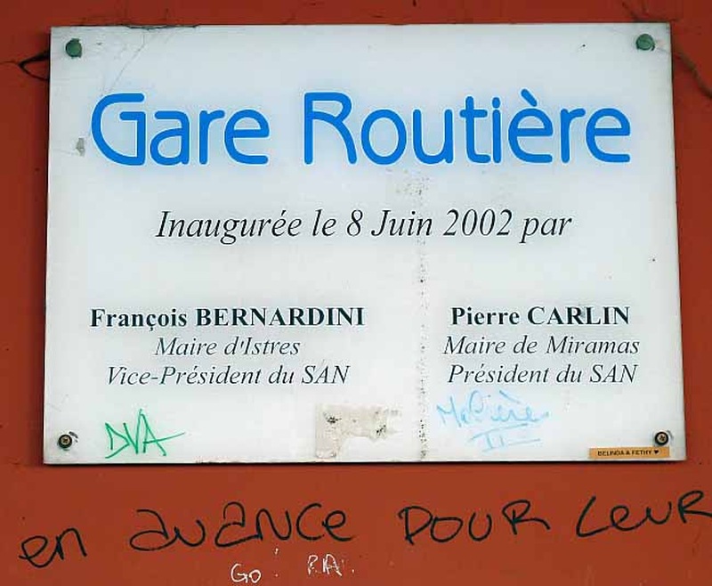 |
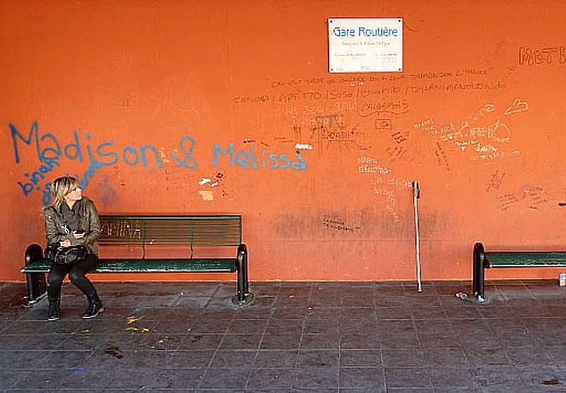
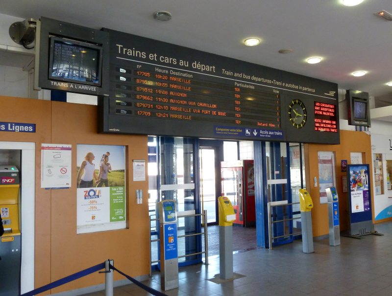
| Above, Istres bus station. Below, Miaramas train station |
 |
|
In case you're wondering why a March 14 hike was completed on April 19 . . . March
14, 2013
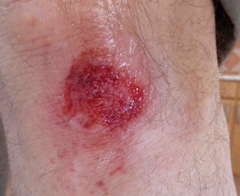
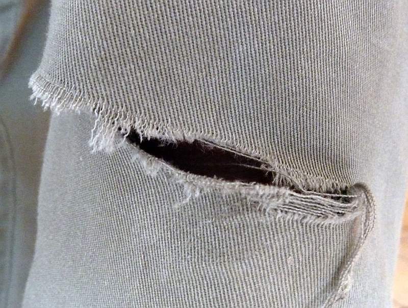
I awoke this morning to howling winds - with rattling hotel signs and the bowing of vegetation. The forecast was basically unchanged (with windspeeds now exceeding 50 mph). But there was also a pointed warning from the local television station that gusts could exceed 75 mph. Coming from the north, I would have a direct headwind for much of today's hike. When I last met such headwinds, I managed to complete the day's hike - but I had no backpack, and I was on the last, i.e., adrenalin-fueled, day of my 2010 hike. Now, three years later, one step out of the hotel told me to forget hiking today. And not just because of the wind; it was teeth-chatteringly cold. As mentioned yesterday, the nearest accommodation on my route was 15 miles away. But that, quite long distance was as short as it was because I'd chosen a desolate, rural route, often on minor lanes and farmers' tracks and besides drainage ditches. It would probably be flat, which also means without windbreaks and sources of help. "You twista your ankle," said Hobson, "and you coulda be a deader." Well, a more populated route was possible but would add miles, and expose me to swaying vehicles. Which route - short but windy and unsafe, or long and trafficked? It seemed to be a case of Hobson's choice. But, last night, I also planned a third option and I knew it was the only realistic one when I walked out of the hotel in full hiking regalia, and found I could hardly stay upright. The replan was, "If you can't hike, don't sit around. That just costs no-show or cancellation fees. Instead, take public transport to your destination. Just make a note of the non-hiking segment, and complete it later." Now, public transportation does exist from Istres-nord to St. Martin-de-Crau, but is not supplied on a plate. How is it researched? Well, the internet identified the routes. Beyond that, this was pretty well the situation that my French is most suited to. (You know, sentences like "Où est la gare, s'il vous plaît?" I can even understand it when people say "transferer", "neuf heures et demi", and "fini, Monsieur".) Two buses using one ticket took me to the town of Miramas, after which a train took me to St. Martin, where I was the only debarking passenger - at an unmanned station with no one to speak to. Here, I figured that the station was nowhere close to the town - a situation which is pretty uncommon in France. I also learned three other things - that I didn't know where to go, that the wind made it very difficult to walk, and that I needed a pee. "It's not often that I watch you dealing with three such delectable problems at once," said my imaginary friend, Hobson. "You mean in a foreign country?" "Makes it even better." I used my GPS to get oriented, learning that the town was a mile to the north. Fortunately I managed to stow it again safely without my gloves blowing away to Algeria. Then I took my pee, a maneuver to be performed while facing in the right direction for the wind without exposing myself to school buses filled with derisively laughing schoolgirls. And then? Hastening to get walking again, since there was nowhere to hide from the awful wind and cold, I did what I often do without even thinking - put on my gloves with my hiking pole under my arm, and hit the road. But this time, with enough wind to make me stagger, I tripped on a ridge - and I literally hit the road - fully assisted by the weight of my backpack. In fact, I landed prostrate, on hard asphalt, and with a considerable thump that nicely bloodied my left knee and tore a four inch hole in my pants. Recovering my composure took a few moments. Then I managed to get up - and stay up - and determined that I was OK, along with all my equipment (electronic and otherwise, remembering that I had barely finished pee-ing when I fell). At a traumatic moment like this, a man naturally turns to his friend to console him. So, though I should know better, I looked at Hobson for his comment. And that's when Hobson growled, "When wind is a problem, try not to fall." Shortly afterwards, and it was barely noon but a mile is a long way in these conditions, I staggered into the Hôtel de la Transhumance in St. Martin three hours before their check-in time. Mercifully they took me in - which I am not sure they could have done in the summer season. There, with the heat on at full bore, I cleaned up my scraped knee, and put triple-antibiotic ointment on it, and a bandaid. I even stitched up my pants, though Hobson wondered if it wouldn't have been better to also stitch up my knee: "While you've got the needle and thread out, that's all." The Hôtel de la Transhumance (I do not know what the word means, but it makes me uneasy) has plenty of heat, coffee-making facilities, and television that includes two English-speaking channels. I am feeling cozy and pampered, but something's going on that makes me question a French claim to be smarter than the Americans because they run their electricity lines tidily underground. So what's going on? Well, the lights here are flickering, threatening a power failure that could deny me the hotel's heat, light and coffee-making facilities, not to mention internet, a hot shower and breakfast. The flickering power is surely the effect of the high winds. But, seeing as the power is supposedly delivered underground here, does this mean that the French have now invented underground winds? |
 |
 |
 |
March 15 and
16, 2013
High winds and bitter cold again canceled hiking - today from St.Martin-de-Crau to Arles. As before, I took public transport to the destination to sleep in my already-booked hotel. That does not mean a lazy day, even if it seems so. Finding the transport between St. Martin and Arles took some late-night research, enabling me to disregard the hotel manager's inaccurate advice (a "local", remember?) about the bus service in his town. Taking care of such details can save a two-hour wait in the cold by missing a bus. This isn't frequent city bus service; this is infrequent BFE bus service - and on a market day when the routes differ. Then, too, just the walk to the bus stop in this weather is a task that an Iditarod dog sledder would respect. The weather seems to follow a pattern of high winds and bitter cold in the morning, followed by some temperature recovery in the afternoon. This has been occurring in dry weather, but rain lies in the forecast also. Through the next seven days, it was hard to find a half-day when the forecast conditions were conducive to hiking. The same kind of weather is occurring up and down the coast, killing any thoughts of doing another part of the hike now, and coming back to hike here when the weather improves. For anyone interested, the Mistral is a well-known, strong and often icy wind in these parts, typically lasting for days at a stretch. Its origin is in the Rhône valley north of here, and it blows south to the Mediterranean. My weather consultant is Steve Burch from Champaign, Illinois. Steve can locate forecast information and past weather data for anywhere on earth faster than a man running from an avalanche. Knowing France, he can also interpret its implications - as in "Time to hunker down in the créperie at the corner of Décarie and Turp". Steve looked up and sent me today's wind data for a few local towns. There were not only high average windspeeds, but gusts on top. According to Steve, this a very stable weather pattern, and it has lowered temperatures way below normal for this time of year. Based on the weather forecasts, he sees it lasting at least a week more. So here I am with some miles lost to poor weather, and expecting to be about a hundred miles behind schedule when the weather clears. Or, put another way, I won't be resuming hiking by the time I should be finished! Meanwhile, I've got cabin fever without the cabin. Now,
for those who inferred that my temporary return to the U.S. was an act
of surrender, I need to remind what a good stash of frequent-flyer
miles can do for a traveler, especially in the off-season when there
are plenty of available airline seats at discounted miles. In a
nutshell, I could fly home
and return when the weather cleared for not much more than the cost of
a
one-night stay in France. So, anticipating a week of bad weather, it
was an easy calculation to see the cost-savings of returning home,
which I did a day or two from now. After about three weeks, I booked my return to France.
April 17 and 18, 2013 In the middle or Ides of March, when I was not far from the Roman town of Arles, I met the brutal winds that sometimes afflict this region, and they arrived with equally-brutal iciness. These conditions were expected to persist for at least a week, so I went home to Tampa, Florida. Almost a month to the day later, and specifically on April 17, I arrived back at Marseille airport, ready to resume my hike. I had covered about 215 miles (65%) of the distance from the Italian frontier to Agde, leaving about 115 miles to go. In a wider sense, including the larger portion of the hike done in 2010, I'd covered about 590 miles (83%) of my goal of hiking about 700 miles from the Italian frontier with France to the Atlantic coast. The little left to do easily persuaded me that I needed to finish the hike, and should get it done now before more bad weather arrived. On April 18, while staying a second day at my hotel in Vitrolles, I left my backpack in the hotel room, took a 20-minute train ride to Marseille St. Charles station, and hiked back to Vitrolles. Thus I walked the Marseille to Vitrolles portion of the hike (read about it here), which I'd previously left to the future for some complex reasons, though for simplicity I still designated it Day A15 according to its route sequence. April 19, 2013 The 50 mph winds (plus gusts) that stopped my March hike occurred at Istres-nord and across the whole region. That day I took public transport to St. Martin-de-Crau, where I fell while walking in even stronger winds to the Transhumance Hotel. To resume the hike where I stopped, I now had to get back to Istres-nord (the Premiére Classe hotel) and walk to St. Martin or elsewhere on my route to Agde. With enough study, I accomplished my repositioning to Istres in about an hour and a half this morning, by taking the 7.06 am train from Vitrolles to Miramas, and then two buses to Istres. This was easiest to do in the early morning when there's frequent service. It was still shy of 9 am when I reached and left my Istres-nord March stopping point to hike to St. Martin. If you look at a map, and I had had plenty of time since March to re-examine mine, you'll see that it's necessary to head to Entressen first (5 miles) at which point there looks to be a "straight-shot" to St. Martin in a northwesterly direction (another 8 miles). The problem with the straight-shot is that it's a rail line and not a road. But there are roads, farmer's lanes, and what seem to be shallow quarry workings that sometimes parallel the rail line and sometimes do not. This is flat, sometimes wet land, and drainage or irrigation canals are commonplace. A farmer's lane that parallels the rail line sometimes stops at a canal on the edge of one of his fields, and "continues" on to his next field but without a bridge over the canal. Also, in this often-windy region, it's significant that there are few sheltering trees. After much study, I reckoned that this route was passable only if one was prepared to accept detours that might make it as long as the major-roads alternative, which was to continue north on the D5 until beyond the A54 autoroute when one could turn left on the D113 and parallel the autoroute to St. Martin. Fifteen miles might actually end up to be the distance in both cases. Because fifteen miles is a hard all-day hike for a geriatric hiker, this matter merited even more analysis. The "wetlands straight-shot", as I began to describe it, had a problem in the event of injury, which could easily take place in a spot no one would find me. But the "highway" alternative could have lots of traffic, and wasn't that much better sheltered than the undoubtedly unsheltered wetlands straight-shot according to maps. In the end, I put the question to Hobson. And Hobson's choice was the "highway" route. I accepted his decision, mainly just to humor him. The wind came up, just as forecast, and was probably 45 mph when I reached the D113, plus there were gusts, though they were not as strong as those that sent me home a month earlier. But the D113 was simply teeming with speeding big rigs getting home for the weekend, while its edges sloped steeply to a drainage ditch just beyond the meager 2 ft shoulder. On these precarious shoulders, I had to stop and make myself as stable as I could for a couple of hundred times as the behemoths roared by, often blowing me back a step. So why would these trucks be on the D113 two-lane undivided highway, and not on the adjacent and parallel autoroute? The answer must surely lie in the government's attempt at capitalism. Having funded the autoroutes intending to recover their investment from user fees, and undoubtedly having over-run their construction budget, or just gotten greedy, they set the toll charges high enough that the real capitalists (the vehicle operators) stayed away - especially since there's a free highway next to the autoroute. Of course, now the autoroute is there, no one will do much to improve the old D113 either. It
was a highway day, and probably longer than the alternative, more
rural,
wetlands straight-shot. The extra mileage was supposed to buy me safety
and convenience. Instead, I ended up with a 2 ft wide shoulder wedged
between swaying big rigs and a drainage ditch - in fierce winds.
The owners of the Transhumance Hotel welcomed me for the second time, and gave me the same nice room. I felt good that I had completed the leg that had defeated me before - and was on my way to Agde. |
 |
| Start Intro Day A17 Day A19 |
© 2013 Daryl May |