| Start
Intro
Day
A20
Day A22 |
| Day A21 - Detours
that might have been |
| April
22,
2013
Saint-Gilles to
Aigues-Mortes
15 miles |
 |
 |
 |
 |
 |
 |
|
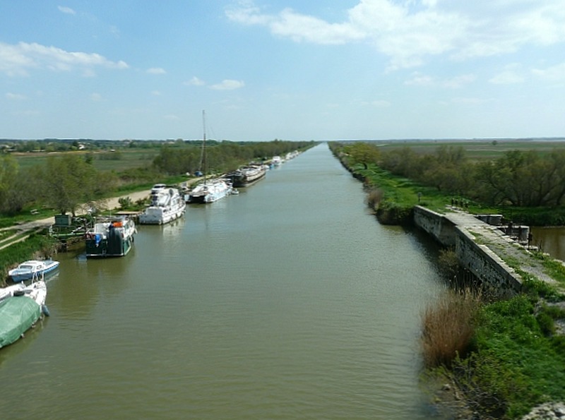
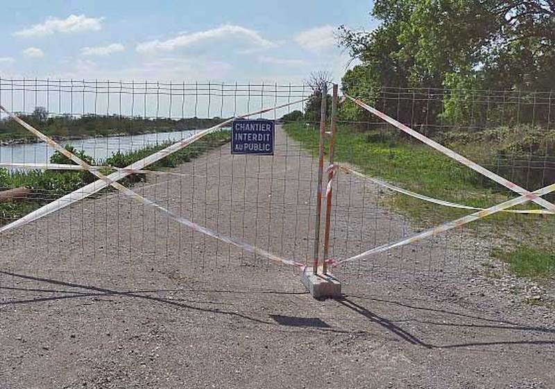
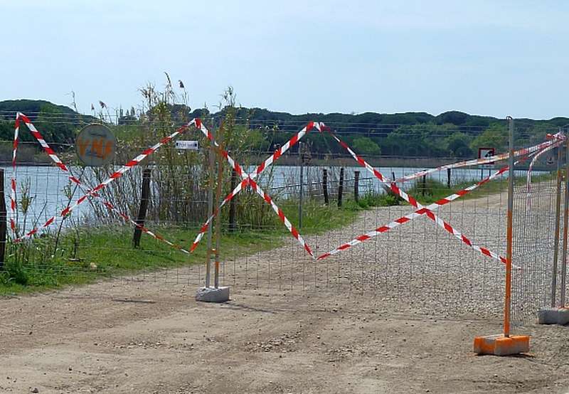
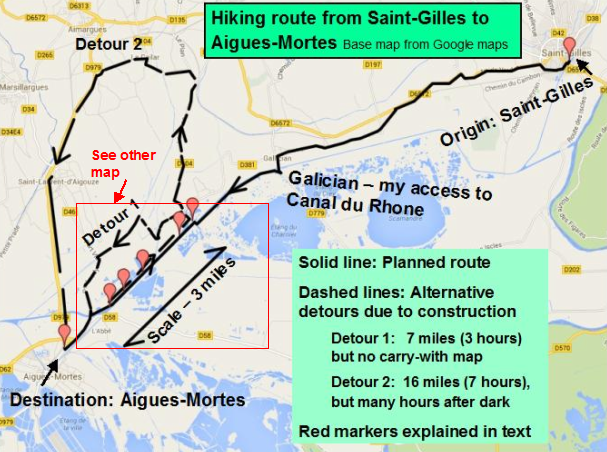
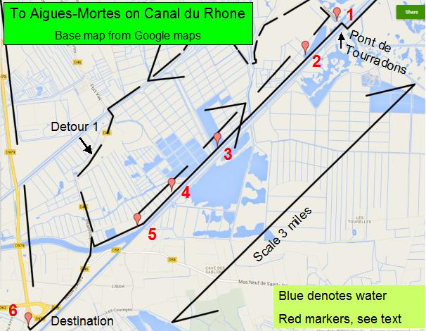
A welcome surprise awaited me this morning. I got an email! One of my readers asked how the French government goes about keeping the Camargue horses purebred. Of course, I'm no expert on this. But local discussions and some reading says they maintain registries of all the horses, distinguishing between those born in the region and those not. The first category is probably held in the higher esteem. For a newborn horse to be registered, it must be seen nursing from a purebred mare within a few hours of its birth. A horse who is deemed not purebred is struck off the registry. If a stallion has been improperly registered, it is struck off and also castrated - a lesson to the owner to be more honest, and one that the stallion remembers also. I cannot vouch for any of this, and suspect there's a whole lot more to it all. Regardless, white horses are almost the only ones you see here, and make a fine sight. It was warm today, and the rather brisk winds were welcome. I planned a 15-mile route to a place closer to my ultimate destination than by any other routing I studied. The key to my planned route was a long 6-mile straight stretch on the towpath of the Rhône canal. Alternate routes all had stretches of road that aimed west or northwest or south rather than in the desired southwest direction. The canal was the key to today's progress, and Hobson thought he had it made. It took me until lunchtime to get to the canal to enjoy its "straight shot" to the town of Aigues-Mortes, my night stop. But now I was ready to enjoy an easy walk in just the right direction. Well, my first surprise was the condition of the towpath. While generously wide, it was sometimes sand and gravel, a surface that I struggled on. And it was rutted by truck tires in many places, which made me appreciate that the weather was dry. The first waypoint on the canal was the Pont des Tourradons about 2.5 miles from my canal start at Gallician. Due to the uneven surface, this took a quite fatiguing 90 minutes. Crossing the Tourradons bridge was now required to switch to the other towpath. The canals do not always have towpaths on both sides, and occasionally the one towpath switches sides. On reaching the new side, I got a shock. A towpath gate had been lowered - see Marker 1 on the map below, though I did not photograph it. A sign on the gate announced the blockage of the towpath in just 900m, which is 2800 ft or a little more than a half-mile. Leaving the canal now just 3.3 miles from the next bridge which crossed to Aigues-Mortes would have required a significant detour on roads, having already covered some 11 miles. I was quite tired already, and my heart sank. I have walked 20 to 25 miles on very few occasions, and been soberly impressed each time. Was that now in store? There was no one to ask. And only one palatable thing to do, which was to walk up to the barrier supposedly 900m away, and decide then. To abandon the canal now would save me only two times 900m, or just over a mile. At the 900m point (Marker 2) there was no sign of a barrier. I walked a few hundred meters further, and still saw no barrier. At that point, I debated whether to continue or turn back, but was far enough beyond 900m to start to believe there was no barrier - so I pressed on. Well, there was a barrier. It lay about 2 miles beyond the Tourradons bridge (Marker 3), by which time my destination of Aigues-Mortes was visible. This barrier was more emphatic than the one before, meaning I had to struggle to get around it. Moreover I could see evidence of construction ahead. Now there are at least two reasons for towpaths to become impassable. One is when the banks have collapsed and there is just nowhere to walk. The other is when they're building some sort of connecting waterway to an adjacent river or lake, possibly planning a future bridge to carry the towpath when the rest of the construction is finished. Both were real possibilities here: the opposite bank showed considerable signs of erosion under the forces of the 300 ft barges I'd seen; and there were lakes on my side that could easily have merited sharing water with the canal. But the one thing that makes a blocked towpath a nightmare is when there is water or marshland beside the towpath, and nowhere to exit except at the bridges that cross the canal, which might be widely separated from one another, even by miles. A blocked towpath in those circumstances means a retreat the way one arrived, or at least to the previous bridge assuming that the bridge's access road goes somewhere useful. Still, with a little over a mile to go before my planned departure from the canal, I was too far along to go back. In fact, I started to look for patches of grass to spend the night on, seeing as the sun was low above the horizon. I put swimming out of my head quickly, but wished I'd seen more boats to try to hitch a ride on. Next, the signs of construction became very real. Large pipes, bolted together, were being readied to lower into the canal on floats. Construction trailers and machinery were on "my" towpath! No one was actually working, but that didn't mean the towpath was passable. Two detours were theoretically possible, but neither was practical. I only identified Detour 1 in hindsight, because it involved farmer's tracks and un-named roads below the level of detail on my carry-with maps. A longer detour, Detour 2, could have been navigated using my maps - but was about 16 miles long, which would have required me to walk in the dark for some hours on named but unlit roads, without buildings or towns or people for many miles. In any case, the distance would have been a killer. I pressed on. And then I saw a third barrier (Marker 4), and beyond that a fourth (Marker 5). But, just then, a construction company truck passed a gap in the most distant barrier and headed for me. My exit from the canal was just a half-mile ahead now - and now I was going to get busted! Time to forget even my limited French language skills, and to fake total incomprehension, as in "Je ne comprend pas"? Then, at one and the same moment, I recognized that the final two barriers, physically real enough, had a different intent. They were there to stop pedestrians from entering the towpath from the Aigues-Mortes end. Their very existence signaled that I was through the construction area. The construction worker in the truck gave me a friendly wave. A few minutes later, the canal was behind me - and no 16-mile, 7-hour detour was needed. I had bet against authority and won. But I felt lucky rather than smart. |
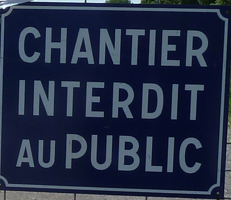 |
| Just
above,
the sign
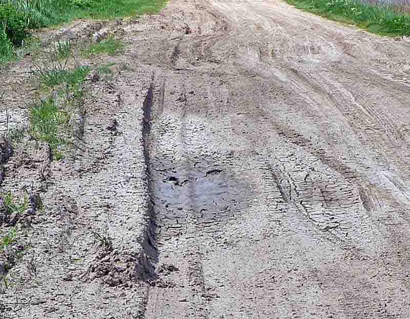
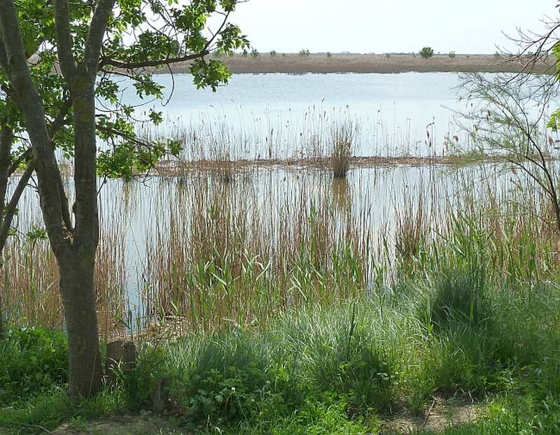
means "Construction forbidden to the public". The first map below shows my day's planned route from Saint-Gilles to Aigues-Mortes, which followed the Canal du Rhône from Galician. It also indicates the two potential detours that towpath construction might have dictated. The red markers are discussed in the text. The bottom map shows the blue areas which are all water. The only roads are shown by white or yellow lines. The bottom picture hints at what the detours might involve. |
 |
| . |
 |
| . |
 |
| Start Intro Day A20 Day A22 |
© 2013 Daryl May |