| Start
Intro
Day
A6
Day A8 |
| Day A7 - Hither and
thither |
| March
4,
2013
Agay to Les
Issambres
14 miles |
 |
 |
|
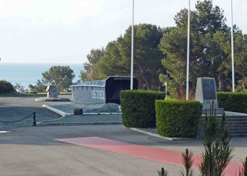
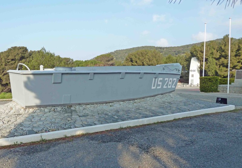
The weather was fine today - though the forecast said it would be bad tomorrow. The roads were definitely better today also. And I've again proved to myself that I can still do 14 miles, which was today's distance from Le Dramont (which is just beyond Agay) to Les Issambres. The beach at Le Dramont, which I reached just minutes into my day, was the site of one of a number of invasion points by the allies in WW2 as part of the hugely-successful Operation Dragoon, which was relatively lightly resisted by the enemy. This August 1944 invasion of southern France occurred over a fifty-mile stretch of coast shown here (Le Dramont is just east of Saint-Raphaël) from which the troops fanned out to capture Toulon and Marseille and points north beyond Lyon and Montelimar. Much of southern France was liberated within a month of these landings. In
Le Dramont
I passed the Eisenhower Memorial to the allied invasion,
which includes plaques to our casualties. The most serious fighting was
close to here. I visited and photographed the site, which is kept in
excellent condition and includes a landing craft. It occurred to me that the access road
for enemy reinforcements will have included the horrible twisting,
cliffside one that I walked yesterday, perhaps allowing the invading
force to establish itself before the defenders arrived. Tomorrow's
route is also through harsh terrain.
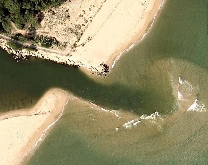
I find that my energy at the end of the day can be sapped by enroute challenges. My challenge today occurred in San Raphaël, the largest town on today's route. I got lost, and wasted an hour going hither and thither at the direction of locals all anxious to help. That hour was equivalent to an added 2 miles. The problem was that the coastal road ends in the vicinity of nearby Fréjus airport, so you have to go inland and, in fact, go around (i.e., north of) the airport before getting back to the coast. It seemed such a litle thing to take an arterial called avenue Victor Hugo to accomplish the first leg of the airport circumnavigation. Such a little thing that I resisted getting out my tablet and tarrying while getting a GPS dot on my map, and going on from there. Instead a succession of locals - including two local gendarmes - assured me that avenue Victor Hugo only ran east towards Cannes (it doesn't). They said I needed to return to the coast now because the coastal path runs westwards without interruption to where I want to go. But in fact I knew that the coast was interrupted by a river mouth south of the airport with no nearby bridge, which was the reason that I had to go around the airport. Heading north and around the airport made sense, in any case, once I had gone north enough to get past Fréjus's port. In the end, I took a road that had to intersect avenue Victor Hugo, if it existed, and in this way encountered rue Victor Hugo, which led to the avenue of that name shortly afterwards - heading around the airport as I knew. Just possibly - and to humbly concede that I could have been wrong, just maybe, for once, and this time only, and without setting a precedent of course . . . let me present my evidence for why the coastal footpath was interrupted by a river mouth. My evidence is the picture from Google maps that is shown on this page. Could L'Argens river mouth have been fordable? Could there even be a bridge there? The map data are as recent as 2013, and thus taken weeks at most before my hike. I didn't want to walk there and chance it. One slip, and no electronics! It didn't help that I got lost in and around the
produce market, near the railroad tracks, and there were construction
detours everywhere. That's partly where the "hither and thither" came
in.
Of course, if I were more quick-witted, I would immediately have remembered that Raphaël was an archangel and protective traveling companion. Raphaël was also a healer whose medium was water. Thus, quite clearly, at Saint-Raphaël I would have been rescued from being lost, and delivered from any evils that L'Argens river might have caused. There is nothing better than divine intervention to keep a hiker on track. As far as staying on course, I always thought I'd get an accurate answer quickly when asking the locals for the main road to the west, or I would have delved for my tablet and sorted myself out in short order. Those locals all seemed so convincing. And that reveals the heart of the problem. A local who is advising a stranger can talk with conviction even when he's wrong, and has no one to answer to for his misdirections. Moreover, he receives hearty thanks just for opening his mouth and pointing. In my next life, I will be a local giving directions to strangers. In all seriousness now, defining one's route is one of the finer pleasures of hiking. (Getting lost is a lesser pleasure.) On an earlier hike I needed to establish the fordability of the River Parrett at a place called Combwich Reach, which is quite far from the nearest bridge. Local expert Yvonne Haggett was able to dissuade me, at the same time presenting a lucid, learned and literarily-elegant brief that well-intentioned locals everywhere should be tasked to read before directing people. The Logis hotel La Provençal in Les Issambres is nice but expensive. Dinner would run me $45 for two courses, and breakfast $15. It's Monday evening in a village and I could find no food around except for an honest, state-subsidized baguette. It went well with my canned mackerel in mustard sauce for dinner, and I saved a foot of baguette for breakfast, if I can't find anything down the road. |
 |
|
Aerial
view (courtesy of Google maps) of the L'Argens river
mouth at Fréjus airport. Could I have risked crossing this river while
carrying a backpack and electronics?
|
| Start Intro Day A6 Day A8 |
© 2013 Daryl May |