 | My Long Walk in France From the Mediterranean to the Atlantic in 2010 |
| France intro
< Previous page Next page > | |
| But why here? | |
 | |
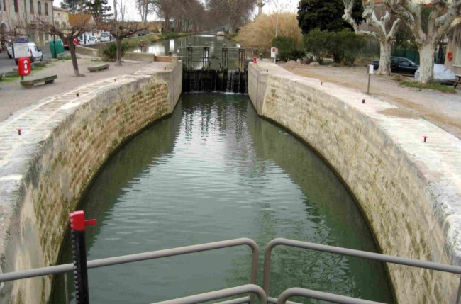 | |
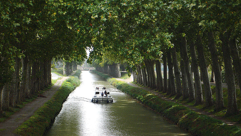
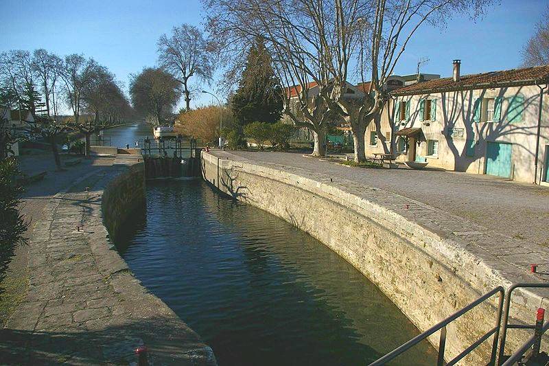
| Top: a shot of the Canal du Midi licensed for copying © Peter Gugerell. Above: the Villeneuve lock showing the curved sides for structural strength. | |
I am an engineer, a navigation nut, and a geek. That unfortunate combination explains lots about my plans. The engineer
As an engineer, the Canal du Midi holds massive appeal. Discussed even in Roman times, its planning dates to 1516 when Leonardo de Vinci helped King Francis I survey a route to "extend" the River Garonne (which runs from Toulouse to Bordeaux) eastwards from Toulouse towards the Mediterranean. That and later planning was thwarted by the difficulty of supplying the proposed canal with water, given that its inland path was above sea level allowing water to rapidly drain away each side of the continental divide. That problem was solved by Pierre-Paul Riquet about 150 years later. As Wikipedia puts it: At the age of 63, Riquet started this great enterprise, sending his personal
engineer, François Andreossy, and a local water
expert, Pierre Roux, to the Montagne Noire to work on the water supply. Some of
Clerville's
men with experience in military engineering came, too, to build a huge
dam [in those mountains] . . .This massive dam, 700 metres
(2,300 ft) long, 30 metres (98 ft) above the riverbed
and 120 metres (390 ft) thick at its base was the largest
work of civil engineering in a century in Europe . . . The
newly built body of water, the Bassin de St. Ferréol, was connected
to the Canal du Midi with a contoured channel over 25 km long, 3.7 m (12 ft)
wide . . . This supply system
successfully fed the canal with water where it crossed the continental divide,
replacing water that drained toward the two seas. The system was a masterpiece
of both hydraulic and structural engineering . . . The canal as a whole was built on a grand scale with locks of length 30.5 m (100 ft) oval in construction, being 6 m (20 ft) wide at the gates and 11 m (36 ft) wide in the middle. This design was intended to resist the collapse of the walls that happened early in the project. The oval locks used the strength of the arch against the inward pressure of the surrounding soil that had destabilized the early locks with straight walls. Such arches had been used by the Romans for retaining walls in Gaul, so this technique was not new, but its application to locks was revolutionary and was imitated in early American canals. The Canal du Midi was opened officially as the Canal Royal de Languedoc
on May 15, 1681. It was also
referred to as the Canal des Deux Mers (Canal of Two Seas). It
eventually [left] Riquet . . .with huge debts and he died in 1680, just months
before the Canal was opened to navigation. His sons inherited the canal, but the
family's investments were not recovered and debts not fully paid for until over
100 years later.The canal was well tended and run as a paternalistic enterprise
until the revolution. When opened, the Canal du Midi is said to have been the largest
engineering enterprise
since Roman times. (Perhaps that claim can be challenged by the Great
Wall of China?) Women as well as men worked on its design and
construction. And it's been improved since, with aqueducts to
cross rivers that once had to be dammed to enable boats to cross them
at the same height as the canal. It enabled an intra-France bypass of
the long,
sometimes-stormy journey around the Iberian peninsula and once-hostile
Spain, saving some 1400 miles (2200 km). Yet its engineering
and geopolitical significance is not well-known outside France. In
recent years, the Canal du Midi, now a World Heritage Site, has been
discovered by pleasure boaters. It must make for great if leisurely
boating.At its easternmost end, you can debate where the canal ends. There are branches that access the Mediterranean at Agde (closest to Toulouse), Marseillan, and the Etang de Thau (Lake Thau) at Sȇte. The significance of Sȇte is that it is also the end of the Canal du Rhōne. As its name suggests, the Canal du Rhōne runs east from Sȇte to access the River Rhōne (and tributaries) that run north-south from central France to the Mediterranean west of Marseille. Thus the canals on my hike are links in a waterway system that connects not just the Atlantic to the Mediterranean but also to central France. Beyond central France, other waterways comprised of canals and rivers provide further connections through Germany to the Baltic in the north and the Black Sea to the east. You can, indeed, go by boat from Rotterdam on the North Sea to Istanbul - inland. I selected Agde as my start point, but Marseillan or Sȇte would have been quite as logical. The navigation nut
My navigation interest is hard to explain. Perhaps it's due to childhood sightings of ocean liners. Or my avid reading of naval adventures. If you have ever studied the significance of the sextant and its predecessors, you'll know how inaccurate timekeeping (yes, timekeeping) stymied the determination of longitude. The development of the chronometer eventually solved the problem. As few people know, sextants were used even on commercial jets when crossing oceans and unpopulated land masses outside radar surveillance and airways. With that as background, Hobson likes to visualize himself on a map when crossing oceans and continents. Equipped with a modern GPS, a trip from the Mediterranean to the Atlantic holds interest beyond the vin ordinaire and brie that will sustain him physically along the way. The geek
So what does the geek add to the engineer and the navigator? In years gone by, navigators used paper maps, and engineers captured their impressions using Polaroid or older cameras, and created manuscripts in longhand which, if ever typed, occurred on sit-up-and-beg clattering machinery. Trip records were sent home using snail-mail, and hiking partners met up using Poste Restante and the occasional deathly-expensive payphone. Not so today. Navigation is by GPS on electronic maps, photographs and words are created and stored electronically, and sent home on the Internet. All this works (or doesn't work) on compact machinery such as wifi-, GPS- and Windows-equipped PDA-phones and Netbooks. I am an early adaptor of all this, and I mentioned "doesn't work" as a hard-earned warning to myself and others. It takes me as much time to prepare and debug all this gadgetry as it does to make the hike itself. You could argue that it's not worth the effort, but I find the effort interesting and rewarding. Once on the hike, it's all so much more efficient than the older alternatives. As one example, long-distance hikers using paper maps generally have to create a mailing project because the totality of their maps are bulkier than they can carry. They mail old ones home and (hopefully) receive their new ones along the way. Many an accommodation establishment has been saddled with paper maps that did not connect with their intended owners. Many intended owners have then resorted to road maps that inevitably took them on less-interesting paths. And, by the way, paper maps - and you might need dozens - are as expensive as electronic maps. Among electronic maps, Google Maps are free, and are fast becoming versatile enough for hiking purposes. When Hobson steps out of the house, he will have an electronic powerhouse in his bellypack. He will steer his way effortlessly along rural paths, always choosing the correct side of the canal. He will phone ahead about accommodation, connect to home with the Internet (and Skype), and even check on reservations. If you can read the day-by-day narrative of this hike, it will be because Hobson uploaded this log successfully. That, of course, is the plan. Experience says to expect problems. As well as equipment failures, there are always manifestations of Murphy's Law. If Hobson mentions that he walked five miles along the canal with towpaths both sides, and then the canal runs through a tunnel with a towpath on just one side . . . Murphy's Law will ensure that Hobson's towpath ends at a rockface. Hobson is resourceful and Hobson will come up with a plan. But swimming across canals in winter is not one of them. Which is just one* reason that good navigation matters. | |
Recommended reading
Two good books for hikers, bikers and boaters are: "Canal du Midi" by Jean-Yves Grégoire (Rando Editions, France, 2007), and "Voies navigables du Midi" by Par C. Vergnots (Editions Cartographiques Maritimes, Le Perreux-sur-Marne, France, 1986) The links take you to the book jackets. The first book is for hikers and bikers, and is in French. It describes the route and the sights along the way. The second book is useful for hikers and bikers but especially for boaters. It's in several languages, and describes the canals in detail. |
|
| * The other reason, of course, is survival - though maybe not on this hike. When heading out of Fort William in Scotland on the West Highland Way, on an icy day with snow and almost no other hikers around, I came across a fork in the path that wasn't on the map. A short distance down one of the alternative paths, the GPS was able to confirm I was on the right one. Some hours later, when worn out and in fading daylight, I had to find the right path that descended to Kinlochleven. There were all too many half-acceptable alternatives that would have been OK for younger folks with stronger ankles, or earlier in the day in better weather. But I knew this descent was several hundred feet in a very short distance. Getting lost or injured were just not acceptable. The GPS told me when I had found the right descent point. | |
| < Previous © 2010 Daryl May Next > | |